Field trips
Upper Biebrza Basin :: Lower Biebrza Basin :: Middle Biebrza Basin :: Measurements
Day Two - Tuesday (15.06.): "Górny Basen" - Upper Biebrza Basin
It will be a half day field trip (see an overview map) to explore the Upper Basin of the Biebrza Valley. Several characteristic for the area study sites will be visited during the trip. The description and explanation of the most important and specific features and relationships of the vegetation-soil-water system will be given on site. The trip will be focused on the following aspects:
vegetation:
- characteristic vegetation of calcareous mires (Szuszalewo village, Lipsk vicinity):
- effects of water feeding on vegetation development: calcium indicators, rainwater accumulation on hummocks with bog vegetation in the middle of depression, option: influence of surface water close to the river,
- paleobotanical data, peat borings and stages of mire development,
- influence of management and effects of abandonment (a gradient from managed fen meadows near the houses to abandoned ones further away);
- characteristics of soil profiles associated with characteristic vegetation;
- collection of hydrologic data in wetland areas:
- gauge stations - measuring of surface water level (Sztabin),
- explanation of the groundwater data collecting system (piezometers and divers, Szuszalewo village),
- problems of an altitude determination in wetlands (GPS and levelling measurements, Szuszalewo village).
Day Three - Wednesday (16.06.): "Basen Środkowy" - Middle Biebrza Basin
It will be a half day field trip (see an overview map) to explore the Middle Basin of the Biebrza Valley. Several characteristic for the area study sites will be visited during the trip. The description and explanation of the most important and specific features and relationships of the vegetation-soil-water system will be given on site. The trip will be focused on the following aspects:
vegetation:- characteristic of Molinion meadows (vicinity of Woźna Wieś village):
- effects of extensive management on drained sites,
- paleobotanical data, peat borings and stages of mire development,
- understanding vegetation development in terms of nutrient limitation (N, P, K), influence of mowing;
- characteristics of bog forest and poor fens (Czerwone Bagno - Grzędy reserve):
- effects of rainwater feeding, bog species vs. fen species,
- paleobotanical data, peat borings and stages of mire development,
- discussion on trees impact on peat accumulation (increased evapotranspiration lowers the water level).
- characteristics of soil profiles associated with characteristic vegetation;
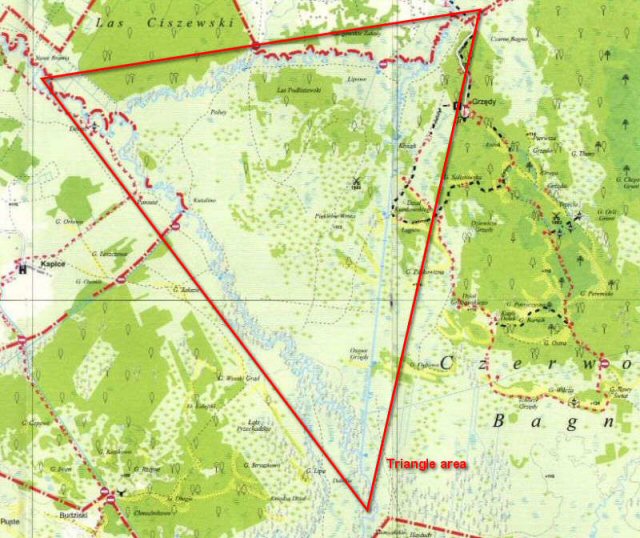
- characteristics of surface water system in wetlands, its changes and influences on and consequences for nature (Triangle area - Jegrznia\Ełk\Woźnawiejski Channel),
- problems related to re-naturalization of surface water (Triangle area).
Day Four - Thursday (17.06.): "Basen Dolny" - Lower Biebrza Basin
It will be a half day field trip (see an overview map) to explore the Lower Basin of the Biebrza Valley. Several characteristic for the area study sites will be visited during the trip. The description and explanation of the most important and specific features and relationships of the vegetation-soil-water system will be given on site. The trip will be focused on the following aspects:
vegetation: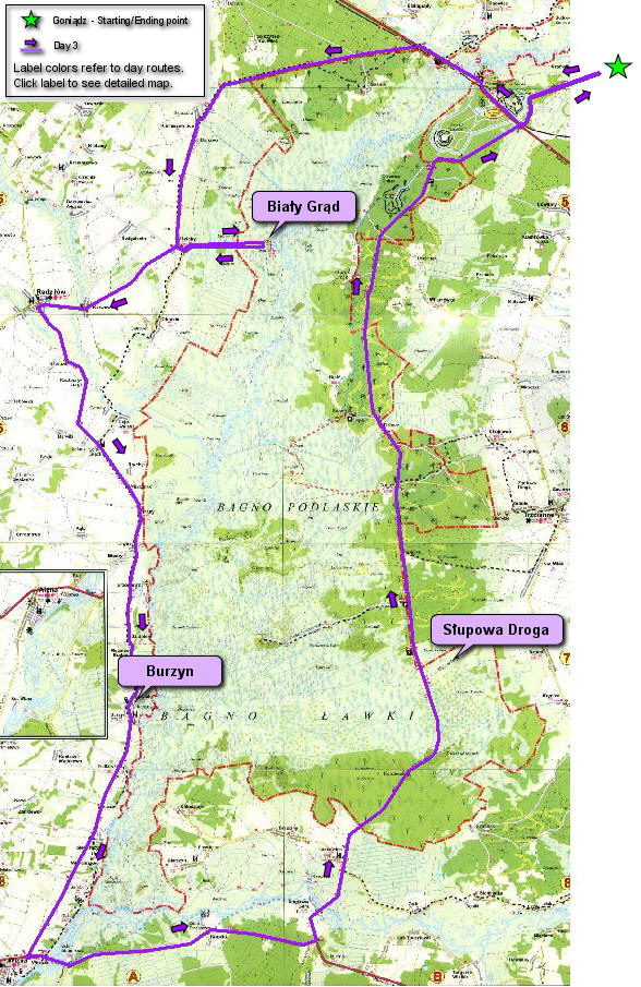
- characteristics of flooded communities on mineral soils: tall sedge vegetation (Magnocaricion) and nitrophilous pastures (Agropyro-Rumicion, Biały Grąd area):
- vegetation structure as a condition for suitable bird habitats,
- characteristics of sedge-moss vegetation near the valley margin (the Tsar road area):
- effects of reed and scrub encroachment,
- paleobotanical data, peat borings and stages of mire development,
- examples of mowing management re-established; discussion of short-terms effects.
- characteristics of soil profiles associated with characteristic vegetation;
- rivers and wetlands, floods and floodplains - relationship and interaction issues
- floodplain - flood extent relationship (Biały Grąd area),
- characteristics of flooding in the Biebrza Valley: frequency, water level, duration (Biały Grąd area),
- ecological role of flooding (flood pulse concept, Biały Grąd area),
- spatial relationship (panorama) of the floodplain and the swamp (vicinity of Burzyn village),
- nature of flood in the Lower Basin: a role of the Narew River and geomorphology on flood duration and forming different types of water during a flood (vicinity of Burzyn village),
- dissemination of the different types of water during flood in the Ławki swamp area (the Tsar road area),
- water level fluctuation during a flood and an average water level above a ground (the Tsar road area).
Day Five - Friday (18.06.): "Pomiary" - Measurements
It will be a full day field trip devoted to presentation of monitoring schemes and measurement equipment and procedures of the wetland areas.
The activities will be focused on two fields: soil (site map) and hydrological (site map) measurements. The participants will visit some of experimental monitoring sites and will practice themselves some of the measurements. The program will be realised in the Middle Biebrza Basin and will include following aspects:
- field monitoring of:
- moisture content,
- soil water potential,
- soil vertical movement,
- surface and groundwater levels
- hydrological measurements and calculations of:
- river water velocity,
- river water table slope,
- discharge and slope calculations